

Every year, approximately 300 million people require humanitarian assistance. However, recent dramatic reductions in humanitarian funding mean only a fraction of global funding appeals are being met. In this resource-constrained environment, artificial intelligence offers a critical opportunity to respond to disasters with greater efficiency, speed, and precision. Much of this potential remains untapped by first responders due to capacity gaps and the complexities of partnering with technology and data providers. The DISHA (Data Insights for Social and Humanitarian Action) Initiative, led by UN Global Pulse, was established to address this challenge. DISHA brings together humanitarian agencies, researchers, and technology partners to collaboratively build and deploy AI products at scale.
A central solution in DISHA’s portfolio enables AI-based analysis of satellite imagery for building damage assessment. Developed with Google Research and implemented in collaboration with the UN Satellite Centre (UNOSAT), the solution was rigorously tested on historic data and entered operational use by UNOSAT in late 2025. The solution has not only been saving analysts’ time and effort, but enabled expansion of analysis coverage for disaster-affected areas. So far, it has been deployed across 11 activations spanning 9 countries and multiple disaster types: earthquakes, floods, complex emergencies, and cyclones, including devastating large-scale disasters like Hurricane Melissa in Jamaica in October 2025. For the Melissa response, the team worked with dozens of satellite images processing 3,776 square kilometres of affected area and assigning preliminary damage scores to over 385,000 buildings. The assessments delivered by AI received similarity scores between 0.84 to 0.94 when subsequently compared to manually produced damage assessments.
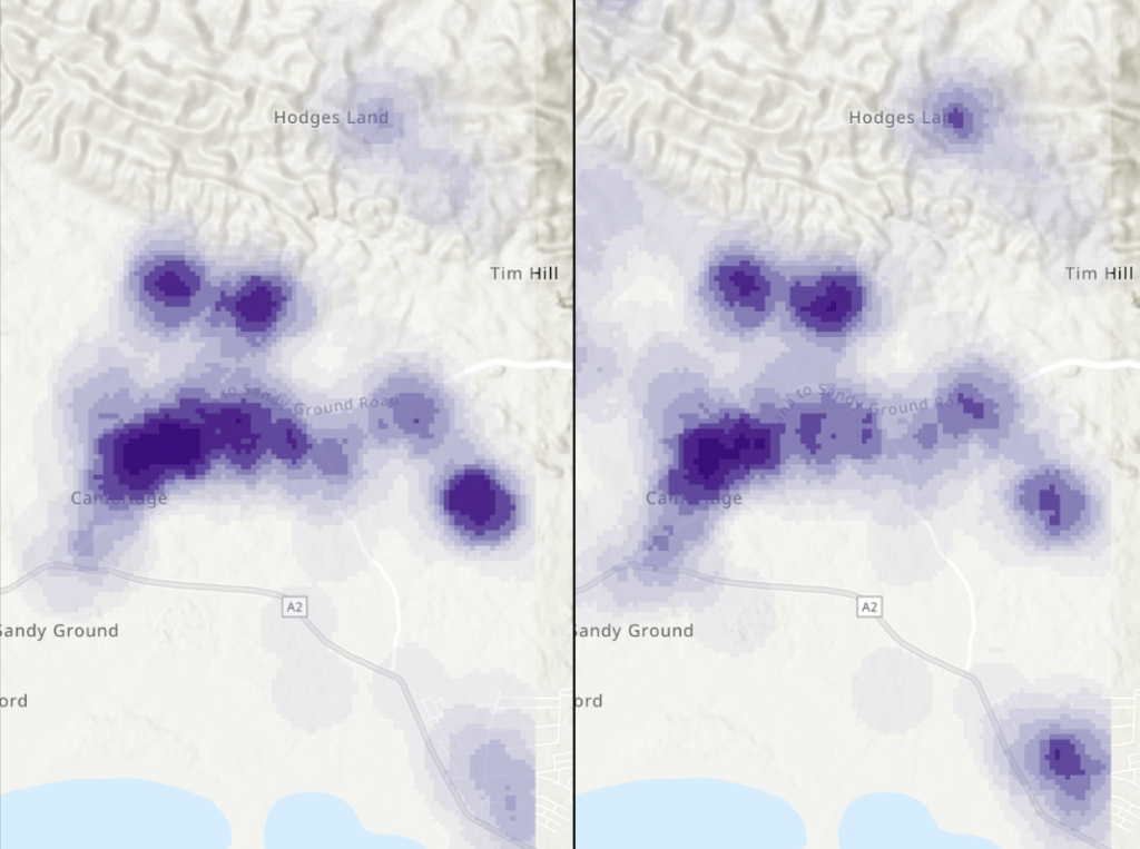
Jamaica – Saint Elizabeth Parish Accuracy Assessment made by UNOSAT. This image compares damage assessment produced by analysts from the United Nations Satellite Centre and Copernicus Emergency Management Service (left) against the outputs of the DISHA Damage Assessment solution (right). The purple colors indicate areas of damage detected, with darker blue indicating higher density of damage. Mathematically, these two datasets can be correlated to produce an r2 score, measuring the degree of ‘alikeness’ between the two. If both datasets were exactly the same, the r2 score would be 1. In this case, the r2 score is 0.91, which is very high and very much suitable for operational use. Note that the SKAI model used as the final step of the DISHA Damage Assessment pipeline primarily detects severe and destroyed levels of damage, which has been accounted for in the comparison.
Hurricane Melissa’s damage assessment results were released publicly by UNOSAT and widely used to inform response and recovery efforts on the ground. For example, the United Nations Development Programme’s Crisis Bureau used the damage maps to produce, within days instead of weeks, an Early Recovery Needs Assessment, including calculating the volume and location of debris to inform clearance prioritization. Debris is often the one of the biggest barriers to communities returning, hence the speed with which this analysis is produced is directly related to how quickly recovery efforts can begin. UNDP estimated that Melissa left behind more than 4.8 million tonnes of debris or the equivalent of approximately 480,000 standard truckloads across western Jamaica. This analysis was referenced in the Prime Minister Holness’s briefing to Parliament, enabling debris removal effort, as well as restoration of access to roads and essential services.
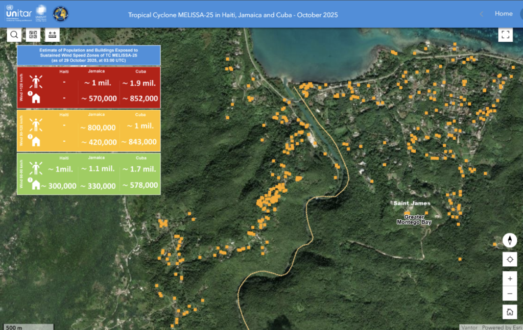
Buildings damaged by the tropical cyclone Melissa identified by the DISHA AI-assisted Damage Assessment solution. Source
Product improvements that ensured operational readiness and high performance
As part of Google Earth AI — a broader effort to transform complex planetary data into actionable intelligence — Google Research granted DISHA pro-bono access to the latest Open Buildings and Building Damage Assessment Models earlier this year. These models, fine-tuned versions of Google’s Remote Sensing Foundations (RSF) models, were integrated into the DISHA pipeline to significantly improve its performance and allow for a tailored approach based on disaster type. This integration will improve the workflow efficiency and precision for all UN humanitarian agencies using the DISHA Damage Assessment product.
The DISHA team also improved the labeling tool for fine-tuning damage assessment models to specific disaster sites. In addition, DISHA overhauled the Damage Assessment product’s user experience with an intuitive graphical interface, simplifying onboarding for analysts without data science expertise.
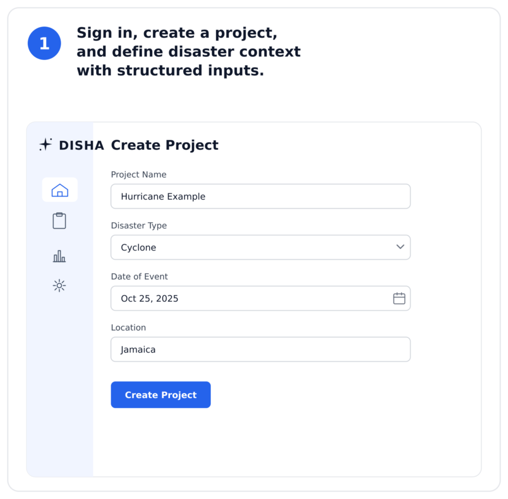
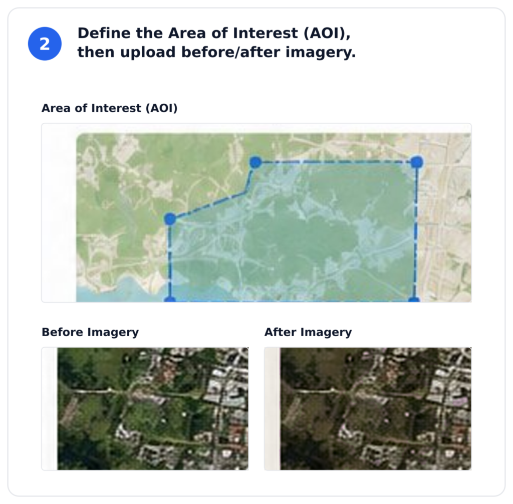
The new interface empowers teams to run end-to-end workflows and leverage AI-driven insights where they are needed most. The following steps can now be completed entirely within the DISHA interface:
- Sign in, create a project, and define disaster context with structured inputs.
2. Upload before/after imagery and define the Area of Interest (AOI).
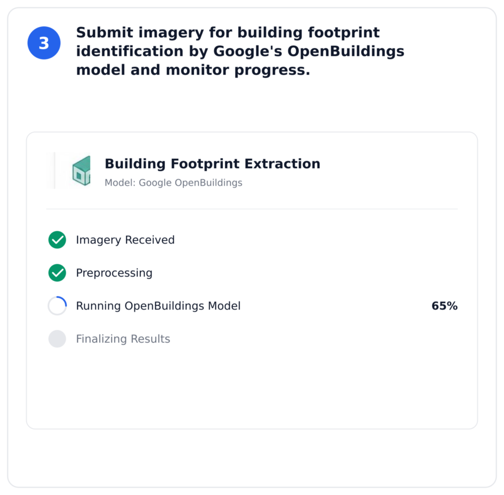
3. Submit imagery for building footprint identification by Google’s OpenBuildings model and monitor progress through intuitive status indicators.
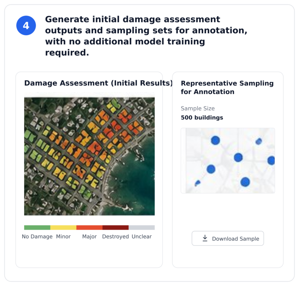
4. Generate initial damage assessment outputs and sampling sets for validation, with no additional model training required.
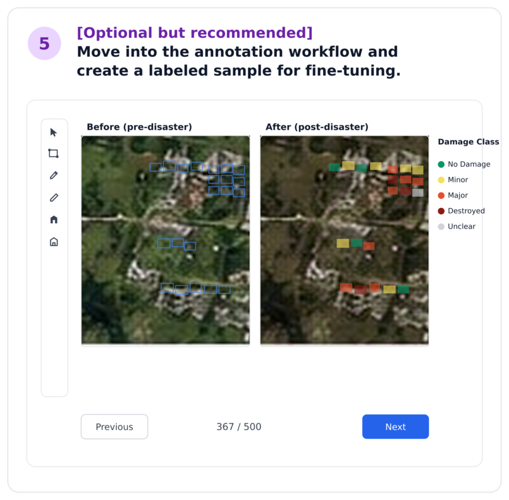
5. [Optional] Seamlessly move into annotation workflow and create a labeled sample for model fine-tuning.
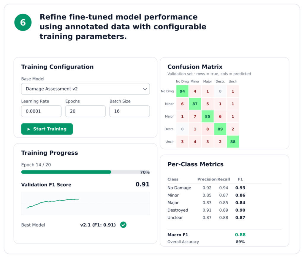
6. Refine fine-tuned model performance using annotated data with configurable training parameters.
Get Involved
In the critical hours following a crisis, first responders must make rapid decisions to prioritize assistance. DISHA and its partners work to ensure humanitarians are equipped with the timely, reliable insights needed to help communities recover as quickly as possible.
If you’d like to see a demo of the DISHA Damage Assessment product, or request access for UN humanitarian teams, please get in touch with us by emailing disha@unglobalpulse.org.
Contributing Team
UN Global Pulse
Data science and engineering: Wesam Al Nabki, Radityo Eko Prasojo, Rajius Idzalika, Muhammad Tomaz Logar, Vanessa Maigné, Rheza Muztahid, Muhammad Nugraha
Product: Andro Kortis
Strategy and program leadership: Katya Klinova
Legal: Keepa Hipango, Vinesh Winodan, Caroline Alewaerts
Executive Sponsors: Kersten Jauer, Talea Von Lupin
UNITAR UNOSAT
Program management: Lars Bromley
Data Scientist: Erika Gutierrez
Executive sponsor: Mukul Bhola
Analysts: Max Dean, Vanessa Guglielmi the whole UN Satellite Centre team
GOOGLE
Aaron Ogle, Alex Diaz, Avinatan Hassidim, Gabriel Doss, Gal Weiss, Jihyeon Lee, Joseph Xu, Juliet Rothenberg, Krishna Sapkota, MohamedElfatih MohamedKhair, Natalie Samson, Olivia Graham, Reuven Sayag, Ronit Levavi Morad, Stephanie Rees, Tomer Shekel, Waqas Burney, Wojciech Sirko, Yossi Matias
1The measure of similarity, or r2, is 0 when the two sets being compared are fully distinct, and 1 when they are perfectly identical. Similarity scores above 0.8 are considered very high, with respective assessments meeting the bar to be operationally usable.